GPS modules have appeared in phones for a long time. And almost immediately from the moment they appeared, many had a desire to use their smartphone as a full-fledged navigator. And this is quite natural, because a properly installed and correctly configured navigator in a smartphone can easily replace a conventional stationary GPS receiver.
And this is already a significant savings for your budget, especially since you can use the navigator on your smartphone not only when traveling by car, but also when walking. Get directions to the nearest cafe, find your way in an unfamiliar city, and much more is feasible for a smartphone.
Installing the navigator.
It is quite easy to install a navigator application on your smartphone. There are many different applications that you can search for in the Google store and choose the best for you. So how do you install the navigator on your smartphone? You need to go to the online application store and select a specific navigator, for example Navitel. To start installation, click the "Install for free" button. After the installation is complete, a notification about the successful completion of the operation will appear on the smartphone screen.

In addition to this method, you can also pre-download any navigator on your computer, and only then record it on your smartphone and install it. Before starting to work with the navigator, you must enter the activation key. A license to use the program must be purchased separately. After entering the key, you can make the settings and take full advantage of all the features of the program. You should also take care of the availability of terrain maps for the navigator. You can download them on the Internet absolutely free.
Getting started with the navigator.
At the first start, you should first activate the previously downloaded maps, if the activation did not go through automatically. Then, in the settings, you need to select the most convenient language pack, and also select the units of measurement: miles, kilometers, and so on. And now how to use the navigator on your smartphone. To begin with, you should choose the currently used mode of transport: car or on foot, choose a path: lay a straight line, or along roads. For convenience, it is possible to connect third-party services: weather, traffic jams, up-to-date information about various objects.
Before plotting the first route, you should search for satellites for communication. This can take a significant amount of time the first time. After connecting the connection, you can start full-fledged work. Depending on the navigator used, the mechanism of action will be slightly different. However, the interface is usually intuitive. You just need to indicate the starting and ending points, after which the program will plot the route and will correct movements and give hints by voice messages.
Smartphones have long ceased to be simple "dialers". They have opened up a lot of new opportunities for their owners.
In the first place is full-fledged high-speed Internet access and communication in social networks and instant messengers. But no less in demand is GPS positioning, which we will now discuss in detail.
What is GPS?
GPS is a navigation system that determines the location of the smartphone, builds routes and allows you to find the desired object on the map.
Almost every modern gadget has a built-in GPS module. This is an antenna tuned to the GPS satellite signal. It was originally developed in the United States for military purposes, but later its signal became available to everyone. The gadget's GPS module is a receiving antenna with an amplifier, but it cannot transmit a signal. Receiving a signal from satellites, the smartphone determines the coordinates of its location.
Almost every modern person has at least once used GPS navigation on a smartphone or tablet. The need for it can arise at any time for people of different professions and different occupations. It is necessary for drivers, couriers, hunters, fishermen and even ordinary pedestrians who find themselves in an unfamiliar city. Thanks to such navigation, you can determine your location, find the desired object on the map, build a route, and if you have Internet access, bypass traffic jams.

Offline maps for GPS
Google has developed a special geolocation application for its Android operating system - Google Maps. It quickly finds satellites, develops routes to facilities and suggests alternatives. Unfortunately, in the absence of a cellular network coverage area, Google Maps does not work, since geographic maps are loaded here via the Internet.
For offline navigation, the best solution is to download apps that support offline maps, such as Maps.me, Navitel and 2GIS. You can also install the Maps: Transport and Navigation application for Google Maps.

In this case, you will not have to spend Internet traffic to download maps - they will always be in your device, regardless of location. This is especially true when you are abroad, since the cost of roaming for Internet access is very high.
How to enable GPS on Android?
The GPS module can be activated in the Android operating system in two ways:
- Upper curtain. Swipe down on the display and in the menu that opens, click the button "Location", "Geolocation" or "Geodata" (depending on the version of Android).
- In the Android settings, find the item similar items, move the checkbox to the "Enabled" position.

During the active operation of the smartphone's navigation system, its battery charge begins to be consumed quite actively, so you should take care of additional power sources. For example, when driving, you need to use a car charger, and when traveling by bike or on foot -.
It is also worth remembering that reliable reception of a satellite signal is possible in an open area, so when you are in a room or a tunnel, geolocation becomes impossible. Cloudy weather also affects - because of the clouds, the device searches for satellites longer and less accurately determines its coordinates.

Not so long ago, GPS was the only geolocation system, so in earlier versions of Android only it was mentioned, and the button for activating the service was called that. Since 2010, the Russian one has fully earned, and since 2012 -.
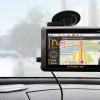
In recent years, the market for car gadgets has been filled with more and more useful and functional devices designed to simplify the life of car owners and improve traffic safety. The best engineers in the world are working to create unique devices designed primarily for drivers. One of the demanded "miracles of technology" is a car navigator, the main task of which is to position the device in relation to a map of the area, and to speed up the process of finding the desired place (houses, streets, cafes, etc.).
It would seem that until recently the map was the best assistant to the driver. But, despite the accuracy of the information, it is inconvenient to use such a "hint", and the very process of finding the right place took a lot of time. With the advent of the navigator, the need to use paper maps has completely disappeared. All that is required is to press a few buttons, getting a picture of the current position and the future route.
But many "newly minted" owners of such devices face a number of difficulties. It is not always clear how to use the navigator and what actions to take to fine-tune it. Let's consider these points in more detail.
How to use the navigator
Buying such a useful gadget is only the first stage. The next step is to learn how to use the navigator, correctly turn on and set the required route. The package, in addition to the navigator itself, includes charging and a manual (instruction) for using the gadget.
To begin with, it is worth examining the contents of the documents, after which you can proceed to setting up. Here the sequence of actions is as follows:
- Power on the device.
- Wait until the navigator is loaded and a picture appears indicating the start of the search for a satellite. Immediately after setting up the signal, the word “Position” appears on the screen. Now you can find out your own position on the map and see the road where the car is.
- To use the navigator and maps, enter the "Menu", and then into the "Settings". There will be a section "Map" where you need to decide on the principle of display. There are two options available - rotation in motion or north up. It is better to choose the first option, which is more convenient to use.
- When determining the route, to move to a specific point by car, go to the "Menu", and then select one of the proposed options. Search is possible by coordinates, through waypoints, by the closest places, by address or by favorite places.
- In the fields that appear, you must indicate the street, house and name of the settlement. The input process is straightforward. It is enough to enter the first few letters, after which the program displays the appropriate options. As soon as the exact address is registered, it remains to give the command to the device "Go". If the program, for any reason, does not find the specified house or street, you can specify the street closest to it, with the building number.
- Wait until the route is formed (it takes a couple of seconds), then move to the goal on the map.
As you can see, using the navigator is not that difficult. But what to do in case of unforeseen circumstances? For example, the device has plotted a route, but it does not fit, or, in the direction of travel, you need to drive to another point along the way. In such a situation, the already formed path should be corrected. Here the sequence of actions is as follows:
- Slide the map to the desired destination. Next, click on the point of interest, and then come up with a name for it.
- Click on the "Find" link, then head to the "Waypoints" section. Now it remains to choose a suitable city and click on the "Show on the map" button. After performing the above manipulations, a map of the settlement with the required place opens. At the end of the setup, it remains to click on the "Enter" button.
Now the program recalculates the previously specified route, after which the distance to the destination point is recorded and the time on the road is indicated. All that is required is to remember to save the map after making edits. This is done by clicking on the special button "Export".
Learning to use the navigator is a matter of a few minutes. Having learned the basics, you can choose a suitable route, and exclude certain sections from it. To do this, click on the link "Avoid when planning a route", then set the required parameters. So, you can "teach" the program not to take into account toll or dirt roads, highways and other types of routes. If desired, it is easy to find out the address of nearby cafeterias, hotels or gas stations. To do this, go to settings and mark POI.
When the gadget is connected to the Internet, the user has access to current data on traffic jams. Thanks to this option, you can save unnecessary time and bypass the traffic jam in a timely manner.
Rules for installing the navigator in the car
Having learned how to use the navigator, you can proceed to attaching it to the car. To make it easier to use the device, you should follow a few rules:
- Make sure that the antenna of the gadget is not covered by metal elements.
- Place the navigator so that, while driving, it does not block your view.
- Calculate the length of the cable. It is important that there is enough power to charge the device.
- Position the gadget so that the sun's rays do not fall on the display.
- Adjust the angle of the screen so that you can follow your route.
The navigator is a constant companion for drivers, fishermen, hunters and mushroom pickers. With its help, you can easily plan a route and find the desired place. If you know how to use a navigator, many tasks become on the shoulder, and tools such as maps or a compass become irrelevant.
Video: How to get directions on the Navitel navigator
If the video does not show, please refresh the page or
If you have never used a navigator before, you might think that, like many other devices, it requires some special skills from its owner and it is easy to learn how to use it. However, this is not at all the case. It is quite simple to install and then set up and work with the navigator, in addition, the set with the device always contains instructions for use, and if not in paper, then certainly in electronic form! So, before you start working with a GPS navigator and go on your first journey with this technique, you need to install it.
How to learn to use the navigator in the car?
So, if you purchase a car navigator, then a stand and a bracket are always supplied with it. A bracket in a car is usually installed on the front of the car or on the windshield. There are other locations, however, with glass and panel being the most common. The terms of use state that the GPS navigator must not be placed where it will interfere with vehicle control, or where it will obscure the view. In addition, the equipment does not need to be mounted where the airbags are located.
Very often, the device is sold with a discharged battery, so it is impossible to use it. In this case, it must be charged either with a mains charger or via a USB cable (it all depends on the configuration). If it is a car navigator, then it can also be charged through a car charger.
Each model of the GPS navigator displays the marked points, the trajectory of the traversed path, the geographical coordinates of the point where you are and, accordingly, your device, as well as your current position. Also, each device has several pages that display various information: a map with traversed paths and points, position in the sky of satellites, a page for me with search and access to various settings, a navigation page, as well as a trip computer page where speed can be displayed movement, distance traveled and so on.
The use of a GPS navigator assumes this function as well. As a rule, for this it is enough to press, and then for a short time hold down the button specially designated for this. The same function can be performed through the navigator menu.
Instructions (rules) for finding a point that you "remember"
In order to find a point, you must first select it from the list of existing ones, and then press the "Go" button. An arrow will appear on the page titled "navigation", which will show you in which direction to move.
What are routes and paths and how to use them correctly?
 A track or path is a trail that you have already traveled. Due to the factory settings, it is saved to the device memory by default. However, this feature can be disabled if you do not need it.
A route or route is one that has been marked in advance by points. In navigation mode, the device can guide you both along the track (Track back) and along the route. You can also first build a route on your computer, and then enter it into the device. But you can also build on the navigator itself.
Track back function - instructions for use
This function is a mode in which your navigator takes you back exactly along the path that was covered. The arrow on the "Navigation" page shows the turns.
How to use a barometric altimeter correctly?
All GPS navigators determine vertical coordinates. In this case, the elevation above the geometrical theoretical figure of the earth is determined. In order to determine the exact height above any surface (including above sea level), it is necessary to use a barometric altimeter. At the same time, it should be remembered that fishermen do not need height, but the presence of a pressure change graph in the navigator.
Video about using navigators
Already from the name of the program, you can guess its purpose. The essence of the utility is to determine the current coordinates of the user based on the signals from the satellites of the world geo-positioning system (GPS) and the cell towers of the mobile network. The reader will be presented with instructions for downloading, installing and initial settings of the navigator application. The process of entering data for a route and following it is also described in detail.
Brief historical digression
In general, the idea of using a device to help a car driver determine his location is far from new. The first predecessor of modern electronic navigation devices appeared in 1920 in Great Britain.
The English version looked like a wristwatch. Special mini-rolls with printed maps of the area were inserted into them, the scrolling of which was carried out manually.
In 1930, a mechanical navigator was introduced for in-car use. Progress did not stand still: in the new device, the scrolling of paper maps took place automatically. Separately, it should be noted that the scrolling intensity directly depended on the current car speed.
Of course, there were no satellites at the time. If the driver turned onto a new road, he had to manually replace one card with another.
The idea of using satellite navigation to determine location came from the launch of the first Soviet satellite in 1957. It turned out that it is possible to use the signal reflected from the apparatus to determine the coordinates and speed of the object.
In 1974, the first GPS satellite was launched in the United States, initiating the development of a global positioning system.
General description of Yandex.Navigator
Yandex.Navigator is a free application that greatly simplifies the life of a car enthusiast who finds himself in an unfamiliar area. Below you will find instructions on how to use Yandex.Navigator.
The main features of the program are as follows:
- Plotting a route from the current point to a specified destination.
- Voice prompts while driving.
- Building the best route between two points on the map.
- View the map offline.
- Search for parking lots in large cities.
- Displays information about traffic jams along the route.
- Voice search function.
The user interface of the navigator is simple. It is not difficult to master it even for an inexperienced user.
System requirements
Before using Yandex.Navigator on your phone, you need to find out if the device meets the minimum system requirements. They are quite democratic. For comfortable operation of the navigation application, it is enough to use a mobile device with the following parameters:
- Processor with a clock speed of 1000 MHz.
- Display with a diagonal of 4 inches (it can be smaller, but it will be difficult to see anything).
- Availability of Wi-Fi and GPS modules.
- Operating system - Android version 4 and higher (there is also a version of the program for use with iOS).
Installation on a smartphone with Android operating system

In order to install "Yandex.Navigator" on a smartphone, you need to perform the following list of manipulations:
- Launch the Google Play Market application store.
- Write the name of the program in the search bar (in our case, it is "Yandex.Navigator").
- Click the magnifying glass icon.
- Tap on the "Install" button.
- Confirm permissions for the navigation software.
- Wait until the end of the installation process.

To start working with the installed Yandex.Navigator application, you need to go to the Android home screen, find the required icon and tap on it to launch the program.
Route planning and other basic functions
So how do you use Yandex.Navigator on Android? Below are brief instructions on how to use the functionality of the navigator application.
To start working with the program and make the initial settings, you need to do the following:
- Start navigation software.
- Wait until the GPS module finishes the procedure for determining its own coordinates.
- Touch the bottom of the smartphone display.
- The menu bar appears. To search, click the magnifying glass icon.
- Set search parameters, find the required address (or coordinates).
- Press the "Let's go" button to start moving along the specified route. To change the scale, simply touch the on-screen plus or minus icons.
- The color of the line of the paved route can change from green to red, depending on the intensity of traffic jams along the route of the car.

Also in the settings you can select the type of map display. There are three options:
- Scheme. Maps drawn by cartographers are displayed. There are street signatures and house numbers. Various organizations are also labeled.
- Satellite. In this case, the background for the map is a satellite photograph of the area. Sometimes it is easier to navigate in an unfamiliar settlement using a photograph.
- People's. This category includes amateur maps created by Internet users. Their use is relevant in the absence of official versions of maps for the desired locality.
Other settings of the navigation application:
- Selecting the type of interface display (day or night). In the second case, the screen colors are inverted for better perception of information in the dark.
- Choice of voice guidance. You can choose one of three options: no voice, female, male.
Using maps offline
Many people working with the application have a question about how to use Yandex.Navigator without the Internet. Without access to the network, you can use maps downloaded in advance from the network. To download them to your device, you need to do the following:
- Activate the Internet connection on the mobile device.
- Launch the Yandex.Navigator application.
- Enter the main menu of the program.
- Next, you will need to enter the name of the city and download the proposed map file.

After downloading, the map will become available for viewing even without a network connection.
Functionality available without an Internet connection
Nevertheless, it is necessary to finally clarify whether it is possible to use Yandex.Navigator without the Internet. It is difficult to give an unequivocal answer to this question. Despite the use of satellite signals, positioning is also carried out with the participation of the Internet and Wi-Fi access points. In other words, without an active connection to 3G / 4G networks, the navigation program will not fully function.
In such a situation, the user can only view the previously loaded maps of certain settlements, while active navigation and route guidance are not available in offline mode.